Eastern Sierras Camping Trip
In the beginning of the summer, one of my good best friends named Emily Cox, who lives in Indiana, talked to me about coming out to visit here in California. After we talked for awhile, we started making plans of what we should do when she is out there. An idea has popped into my head, of something I have wanted to do for a long time. Return to the Eastern Sierras. I started looking for campsites, with a goal of first camping at June Lake. That didn't work, so I went to check out Mammoth. Yeah, that didn't work either. Finally, i found a campsite that has spots open, and that would be at Convict Lake. I made reservations and then talked to Scotty to see if he would like to join in the adventure. Emily, Scotty, and I had a 4 day camping trip, from Aug. 7-10, and I took them to many different places in the Eastern Sierras from Mammoth to Bodie Ghost Town, to much more. Below, is my blog post of our trip. Photos of this blog have been taken by either Emily, Scotty, myself, or a person that we asked to take pics of us, or the random tree or rock or table we used as a tripod :) Hundreds of photos of the trip can be found on facebook.
August 7, 2011: A Drive Up America's Back Road
Emily and I woke up around 7 in the morning, and we finished packing up what we needed in my mom's car, which my mom was nice enough to let me take for our trip. We had a goal to leave by 8, for we had a long day ahead of us. We arrived at Scotty's house around 7:50, packed up his stuff, and say bye to his step dad Ed. Before hitting the road, we stopped off at the local Carls Jr for some breakfast, then fill up the car with gas at Chevron. We got on the road about 8:30, and went from the 210 to the 15 up into the high desert. Once we passed Cajon Pass, we got onto the 395, which we took all the way up to Mammoth. Of course, We had to make a few stops to see some things along the way.
 Our first major stop on our drive up was at the Eastern Sierra Inter-agency Center in Lone Pine. We first parked across from the center, for there was a geocache hidden there, and we wanted to find it. We also had our first good view of the high peaks of the Sierras, including Mt. Whitney. After looking for the geocache, which we found, we took some photos and enjoyed the view before going to the ESIA Center across the street. After a quick stop at the restrooms, we went inside to look around at the gift shop and some of the displays. I got a free map of the Mammoth area in case we would need it. Once we had a good stretch of our legs, we headed out back on the road, with a quick stop at another Carls Jr. for lunch. Our next stop would be would be high up in the White Mountains.
 About an hour later, we arrived in Big Pine, which we turned off the 395, onto the 168 which took us up into the White Mountains, which are east of the Sierras. We were headed to almost the top of the mountain, to see the ancient Bristlecone Pine Trees, more specifically the Schulman Grove. The road up to the White Mountains was very curvy and at a step grade, which I knew that it would be an interesting drive back down. A few miles before we arrived at the Schulman Grove, there was a turn out to see a view point of the Sierras across the Owen's Valley. We stopped to take a look, and of course take pics. Once we explored the vista area, we headed on to the Schulman Grove. When we drove into the parking lot, I noticed a fence blocking cars, and construction going on in behind the blocked part of the parking lot. There was a temp office trailer where people can get information about the Bristlecones. We parked the car, got the stuff we needed, and headed over to the trailer. As we were walking over to the trailer, I was thinking to myself about the last time I had been up at this Grove over ten years ago. I could of swarn there was a nice visitor center here, but it seemed like it was just being built. When we got to the trailer, I saw a sign saying that this day was a free day to explore the Grove. That made us happy, since we all are poor college students. I then talked to the ranger about the visitor center. It seems that a person with schizophrenia had burnt down the visitor center that was here, and they are currently working on building a new facility. The person who burnt down the visitor center was caught down at Big Pine later, trying to burn down the local High School.
 Afterwards, we went out on the 1 mile trail. We thought it wouldn't be that big of a deal since it was just a mile. I got out the GPS unit to get ready to find the two geocaches that were in the area. Things started out good, but we got about 1/4 of a mile out, and we began to get tired, and gasping for air. I looked at the GPS unit, and it showed we were at 10,200 ft in elevation. The highest it had told me during the hike was that we were at 10,350 feet. I knew we weren't prepared to do much at this high of an altitude. Emily lives at 600 ft and Scotty and I live at around 1,500. We continued on the hike but we would have to take stops to regain our breath after awhile. Of course, we took photos of these old trees along the way, sometime as an excuse to rest. I love how the wood of the trees look, and to know that these trees just happen to the be the oldest living organisms on the planet. About 2/3 of a mile into the trail was supposed to be the geocache, located in an area where there are tons of red rocks, which were from the ocean bottom before the mountains were uplifted thousands of years ago. When we got there, strangely the GPS told me we were nowhere near. We decided to head down the hill. When we were near the bottom of the switchbacks, I thought about the GPS, and realized I had entered the coordinates for the cache that was near the parking lot. Scotty and Emily looked at me with a irritated look because that means we would have to go back up the switchbacks to get to where the cache was. We spent a good amount of time looking for the cache, with no luck. Too many different bushes and rock piles it could have been under. The bushes were thorny, so we didn't look too much under them. We gave up, mainly cuz we were tired. Near this point the GPS was jumping all over the place, which made it hard. We continued on the path to the parking lot. We came up to the other cache site, but was too tired to care. We just wanted to go back to the car to sit down. The trees were beautiful as they always have been, and I wish we were able to stay the entire night at the grove, so I could attempt a star trail photograph, but that will have to be another trip.
 We headed back down into Owen's Valley. It took a little longer to get down than up, for most of the way I was driving down in second gear. After awhile I got sick of the slowness of second gear and I went back into auto. Was more fun to drive that way, even though the brakes smelt bad when we got back down to Big Pine. We headed back on the 395, headed for Bishop. We had one more stop before we got to the campsite. In Bishop, we stopped at the Erick Schat's Bakkery. Parking was full, so we parked just a few blocks down, and walked over. We looked around. Emily bought a dinosaur cookie and a cherry pastry that she will have for the next day's breakfast. I bought cheese bread sticks that we would have with our Spaghetti Dinner that we had planned to have the second night of the trip. Didn't buy anything else, because I plan on returning on the way back home to buy bread to take home. We walked back to the car, and headed on the last part of our drive. Our next stop would be the Convict Lake Resort Campground.
 Convict Lake was a new experience for me. Never been to this lake. The turn off for the lake was just next to the Mammoth Airport, and headed up right to the bottom of the sierras. When we got there, we first saw a general store, a few cabins, a big wedding reception tent with chairs underneath, and signs for horseback riding. As we kept driving on, Convict Lake was right ahead of us. The road turned to the left, and followed the lake. After about 500 feet or so, the campground showed up on the left. We found out spot, which was campsite #17, parked the car, and started to set up the camp. It was exciting because I had bought a new 6 person tent before the trip, so this would be the first time using it, and setting it up. After setting up camp, we drove back to the lake to look at it, then we headed off to look at the general store, and to find out where the showers were located. After that quick adventure, we headed back to start a fire, and roast some hot dogs for dinner, have some jello shots that Emily and I made the day before, and have smores. When we got back to the campsite, a deer was right across the street chilling next to someone else's campsite. One thing that was cool was the tall mountain that was behind the lake. It had many cool colors on its mountain side from browns, blacks, and reds. It was a very nice site to see, and you can see it from the lake, the campsite, and the general store.
Once it got dark, and the fire died down, around 9:30. We walked on over to the lake. Taking the cameras of course. We got to the side of the lake, after walking through a small path for about 500 feet from the road, through thick trees. We looked at the stars, and we attempted to do some long exposures. My hopes were to do a star trail while on the trip, but the moon was in the sky lighting it up, so I gave that dream up for the trip. I set up my tripod to try to get some shots of the big dipper. It was hard to work on getting the stars in focus. Scotty was also working on star photos. I had a wireless remote to use for my camera, but the battery was dying, and it stopped working before I get get the settings right. After about 30 mins, we walked back to the campsite, and headed to bed. The next day would be another long and epic adventure.
August 8, 2011: Mammoth Lakes, CA
As the sun filled up the inside of the tent, we all slowly began to wake up. Scotty was the first to wake, and he left the tent to go look around while Emily and I was still waking up. I had woken while Scotty was getting ready to leave the tent, but was still falling in and out of sleep. After about another 45 mins or so, the tent began to get warm, which convinced us to get out of the tent. Scotty was outside eating breakfast at the table. At that point, I had realized that I forgot my cereal on top of the fridge at home. Scotty was nice enough to share his mini wheats cereal. Emily had her pastry from the bakery for breakfast. After we ate, freshened up, and got the campsite cleaned up a little bit, we got in the car and headed to the general store to get some ice for the ice chest, then headed on out to drive into Mammoth Lakes.
Our first planned thing to do in Mammoth was to see Devil's Postpile and then hike what I thought was a 4 mile round trip hike to Rainbow Falls. When we got to the entrance to the national monument, the park ranger informed me that day use visitors were not allowed access to drive into the area. We had to drive down to the main lodge of the ski resort, and catch a shuttle into the national monument. We turned around and parked at the main lodge. We weren't quite sure where to go, but we started walking around. We first ended up in the gondola building that takes you to the summer, then we had learned we could get tickets for the shuttle in the gift store that was located below the gondola entrance. We went to get our tickets, which were $7 a person, and then went outside to see were we get picked up from the shuttle. Once we saw the shuttle pick up, we headed back to the car to grab the things we needed for the hike. While walking to the car, I noticed that the ground was still moist from all the melting snow the area has been experiencing the past month. Emily was looking out to Mammoth Mountain and really wanted to go up there to play in the snow. We got on the shuttle, and headed into the Devil's Postpile National Monument. In route to the Devils Postpile drop off, we got to see some avalanche damage from the winter, and got to see tons of wild flowers that were in bloom. I don't remember ever seeing so much wildflowers to ever be blooming in the Mammoth area, but it was sure beautiful. As we got close to Devils Postpile, I had learned that they have extended the road in the area. Last time I was in the area, in 2002, the road ended at the Devils Postpile parking lot. It seems they have extended it, and there was a stop that took you closer to Rainbow Falls. We decided we would still hike from the postpile like originally planned.
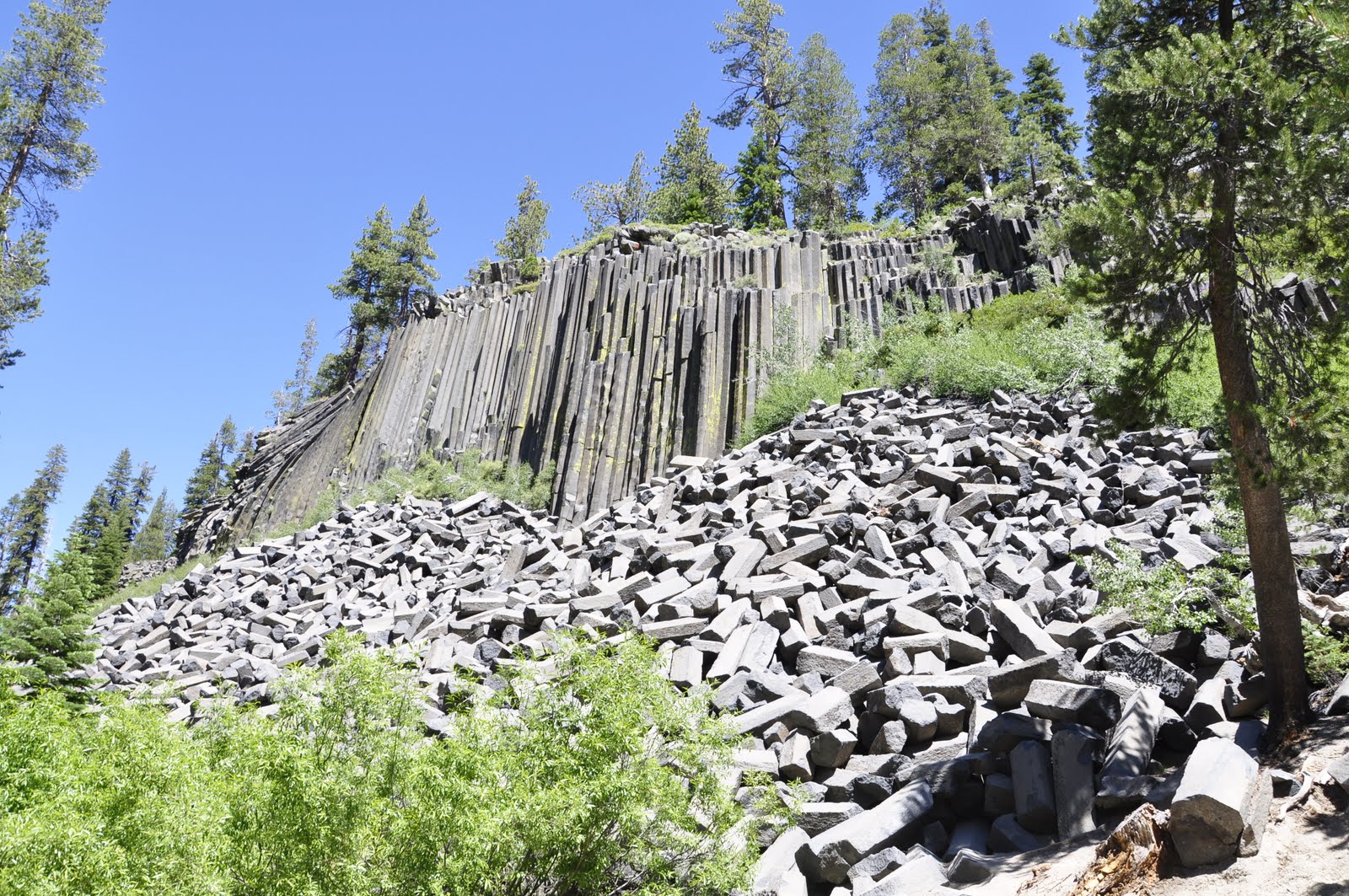
 We got off the shuttle, and headed right on the path to Devils Postpile, while rest of the people stopped at the small visitor center. It was 10:30. As we started on the trail, I had noticed the sign said it was a 2.5 mile hike to Rainbow Falls, when I thought it was just 2. This would make our hike 5 miles instead of the originally 4 mile plan. We didn't care, we were excited to get out into the forest and see the awesome things down the trail. We arrived at Devils Postpile, and we attempted to take photographs but the sun was right behind the postpile. We had decided we would continue on, and take photographs when we come back on the return hike from the falls. Many people were on the trail, which was very surprising. Last time I was here, it was only my dad and I for the entire trial. The trail came across the John Muir Trail, which came from Yosemite, and was headed to Mt. Whitney. About a mile into the trail, we come to the rivers side. We stopped to view the cascades just down in a canyon. Scotty found a way down the canyon wall closer to the water, where he could get a closer view of the river. While we went on his little side adventure, Emily and I stayed at the top of the small canyon, and had a small snack. We noticed that we will be here longer than we thought, and should have brought lunch with us. After about 10 mins, we continued on the hike. The trail we were on, would take us in and out of the Devils Postpile National Monument and the Ansel Adams Wilderness. Last time I was on the trail, I took a photograph with the sign saying the Ansel Adams Wilderness, and I had plans to take another one. If you look at the background, in the forest, many of the burnt trees from the 1994 fire that went through the area had fallen. It was a different area today than what it was back then. As we got close to Rainbow Falls, the amount of people on the trail had grown.
 We had started to hear some crazy amount of rushing water, as we went down some stairs. We started getting excited, and before we knew it, we got to the first lookout spot for Rainbow Falls. There were close to 40 people in the area, so we waited our turn to get to the front to see the falls. The falls were flowing with tons of water, more than what I expected for this time of year. The sun was just in the right spot to were we could see a double rainbow in the mist from the falls. We chilled at the first view point for about 15 mins, then we headed on the trail to the second view point. From the second view point, there were stairs that took you down into the canyon to the bottom of the falls. I was starting to get tired from the hike, and almost wanted to not go down the stairs, because that would mean we would have to go up the stairs, but in the end I said fuck it, and I went anyway. How often do I get a change to be close to an amazing and beautiful waterfall like this? We got down to the bottom, and it was even better than the top view, other than the fact we can't see the rainbow in the mist from this level. We took tons of photos. We wanted a group photo, and we asked a guy in the orange shirt to take it for us. We was quite funny. He first was pretending to take a pic with the camera lens pointing his face, which was funny. Then he officially took the photo of us. He was a nice guy, and he will be known by us as the guy in the orange shirt. After enjoying the falls for about 15 mins, we decided it was time to head on up the stairs and get back on the trail, heading back to the Devils Postpile. The stairs weren't as bad as I had thought. Only had to stop at the halfway point for a quick rest, and then at the top.


 We hiked back to Devils Postpile. Many people were hiking back near us, but when the trail forked off to were it took people to where the bus dropped them off, most people went that way, while we continued the same way we came. As we were hiking back, we began getting tired and hungry. We got to the point were we could hike to the top of the Devils Postpile or go down to the bottom. Emily and I looked at the uphill trail, and out of tiredness, we decided not to go. Scotty on the other hand went to the top. Emily and I got to the bottom viewpoint of the postpile and we found a good tree trunk to rest on. After about ten mins, I decided to get up to take some photos of the postpile. While I was taking photos, I had noticed Scotty at the top. I was surprised to see him at the edge, for I remember it was very dangerous to be near the edge with the slippery basalt top, made slippery when the glaciers of the last ice age polished the rock. While Emily and I were waiting on Scotty, we used our iphones to look up information on the gondola to the top of Mammoth Mountain. We had decided it would be cool to go to the top, and to have lunch up there. It was 1:30 at the time, and from what the website said, we had 2 hours before the gondola shut down for the day. After about another 5 or so mins, Scotty was down with us, and we finished the last 1/2 mile of the hike to were the shuttle would pick us up. Emily and I talked to Scotty and he had agreed about going on the gondola to the top. When the shuttle arrived, it was packed with people already. Probably the people who were lazy, and got picked up at the bus stop for Rainbow Falls, which was just a mile away from the lookout point. We ended up standing for the bus ride, which we a fun experience with the uphill, downhill, and curvy mostly one lane mountain road.
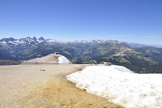 When we arrived back at the main ski lodge at Mammoth, we headed right back to the place were be bought the shuttle tickets to buy the tickets for the gondola, which was $23.00 a person. We got on the gondola and headed to the summit of Mammoth Mountain. The ride was a nice rest from our long hike. We were excited to get to the top to see the view, to play in the snow, and eat. We were starving. As we neared the top, Emily got a phone call, which was a bad time to get a call like this, about issues back home with roomate issues. When we got to the summit, she spent a good amount of time on the phone. I kinda felt bad for her because she was here on vacation, and some drama from home came around. Scotty and I explored the summit of Mammoth Mountain. I went over to the snow, which wasn't all that clean, but it still was awesome to be standing in snow in August. We also took photos of the surrounding peaks of the sierras, which still had a good amount of snow on the top as well. Emily was able to get off the phone and enjoy the summit as well. At the summit, we were 11,056 ft above sea level, which would be the highest we will get on the trip. There were a good amount of mountain bikers that were on trails on the mountain. Scotty went around to the other side of the summit, and Emily and I decided to go check at the cafe. We got inside the building, and found the entrance, only to learn that the cafe had closed about 15 mins before we arrived. At this point, we were tired from the hike, and super hungry. We found Scotty and went back down the gondola. At the main lodge, we saw a restaurant called The Yodler. We decided to just go and eat there. We had finally had lunch around 3:30 pm. We were happy. Their curly fries were amazing by the way.
 After a good lunch, we had decided it was time to head back to the campsite. On the way back, I took a side trip to show Scotty and Emily Hot Creek Springs, which are hot springs that are next to Hot Creek, and was formed do to the magma that is below us. I also wanted to stop at the Hot Creek Fish Hatchery, but as we drove by, it seemed it had been closed for a good amount of time. We found a geocache at the view point of the Hot Springs, but we didn't walk down to get a better look. On the way back to the 395, Emily had me stop so she can take some photos of some cows that were chilling by the road. When we got to the campsite, we grabbed some of our things, then headed to the general store to take some showers. The showers took shower tokens, which we had to buy from the general store. One token was $3.00 and that gave us three mins. I bought two tokens, which were $5.00 and would get me 6 mins in the shower. Since there were only two showers at the place, I let Emily and Scotty go first. While I was waiting I was messing around with my phone. Cell reception was in an out at our campsite, and was better at the general store. Not by much, but I was able to send a few texts to Sarah and get on facebook. Scotty and Emily got out of the shower and they waited for me. I only used one of the two tokens, so I saved the last one for the next day. After the shower, we headed back and relaxed at the campsite. We sat at the table and chilled for awhile. Originally we had planned to have Spaghetti for dinner, but because of our very late lunch, we had decided to push that to the last night. We decided to just have more hot dogs, and smores when we got hungry. We also had some more jello shots. Scotty was nice to share his Amaretto and made me an Amaretto Sour. Lets just say I got a little buzzed that night. While we were sitting there at the campsite, a deer had wondered into the campsite, which was awesome. Emily and Scotty followed them up the hill to take photos, while I stayed at the campsite to keep watch over the fire. As the night went on, we ran out of firewood, and we had gone to sleep, for our trip was only half way over, with plenty more to explore the next day.

 We got in the car, and headed on out to drive about an hour north on the 395 to Mono Lake. My first plan was to take Emily and Scotty to Panum Crater, a volcano near the south shore of Mono Lake, were we were going to find a geocache. I also wanted to go there, because a long time ago, in 1992, my cousins Krystal and Amanda, their family, myself and my family hiked into the volcano to get some volcanic rocks, so I wanted to go again. We got to the 120 east, and drove out to the cinder cone volcano, but must not have noticed any signs, because we ended up driving right past it. We ended up going to the South Shore Tufa area first, which I had planned to go after Panum Crater. We parked, and I paid $3 a person to see the tufas, and we walked on the mile loop trail. The area was just the same as it was last time I was there. The water level was way lower than it should be, the tufas were cool looking, hundreds of flies, and a nice view of the lake. One thing I noticed in the water this time, that I didn't remember seeing in my past visits, were a good amount of Brine Shrimp that was near the shore line. I knew they were in the lake, but didn't think they would be that close. It was cool to see them in the wild for once, and not just in a fish tank at an aquarium or at the Mono Lake visitor center.
 After exploring the Mono Lake Tufa's, we had to give a second try to find the road to Panum Crater. We passed a few dirt roads, and was trying to guess which one would take us to the parking area. We took a dirt road that got narrow real fast, to a one lane road. It didn't seem like it was a type of road to the volcano, but we took it for a few miles. The road then started to turn away from the volcano, so when we got to an open spot, we turned around. We followed the dirt road back, but then saw another dirt road that headed towards the other side of the volcano, so we took that. I was getting nervous on these small dirt roads because many bushes were scrapping along the side of my mom's car while driving on them. I tried my best to avoid them, but I didn't want to get the car stuck on soft sand. The second dirt road we took finally got us to the official road that took us to the volcano. We parked the car, got the GPS ready, and I looked at the damage of the scraps. There were a few good size scratches on the passenger side of her car, which got me worried, but Scotty assured me that they will be able to come out. We hiked into the crater plug trail, which took us right into the middle of the volcano. We got to some switchbacks that took us to the top of the plug inside the crater. From the top, we had to walk to the northern part of the plug. While on the plug, we saw massive amounts of obsidian and pumice in all shapes and sizes. Most of all the rock we had been walking on were pumice, which I thought was really cool. We had found the geocache. From where the geocache was located, we could get a almost an entire full view of Mono Lake and surrounding area. We headed back to the car, and we continued on to our next adventure of the day.
 We headed on out to the Mono Lake Visitor Center. We first stopped off at the junction of the 395 and 120 east to get another geocache, which just happened to be located at something called the Grave of the Unknown Prospector. I believe it was a grave site for some random person who died years ago, when the west was being explored, and they dedicated to all those who lost their lives exploring the west back in the late 1800s. From there, we headed to the Mono Lake Visitor Center, where we had a rest stop, looked at the exhibits, another view of Mono Lake, and looked at the gift shop. Afterwards, we were thinking of having lunch, but didn't really want to make sandwiches, so we went into Lee Vining, and had lunch at Bodie Mike's BBQ. After a nice relaxing lunch on the outside patio, we headed back on the road to our next stop. Bodie Ghost Town. When we got to the 270 junction, I was prepared for a ten mile dirt road that would take us deep into the Bodie Hills, but things were way different. We first had to wait for construction crews to allow us to get onto the 270, because they were having the 395 go down to a one lane road. Once we got onto the 270, it was a new, paved road. Half way on the paved road, we had to stop for a good 20 mins, because they had a portion of that road a one lane road as well for construction going on. After our long wait, we continued on. Finally, we got to the road were it turned into a dirt road, and we went on that for just 3 miles. The road took us to the ghost town.
 It cost $7 a person to get into Bodie, which I had no cash, for lunch took the rest of it, so Scotty was nice enough to pay. When we drove in, I was amazed at how many people were at the ghost town. There were so many people there, that when you were walking through the section of the ghost town were the old hotel, and some shops were, you felt as if the town was still well alive. We parked, but some sun screen on, got water, and our cameras and explored the deserted gold mine city. Scotty and Emily both loved the town. They had no clue what to expect since they had never been to bodie before. This would be around my 6th time to the ghost town, and I enjoyed it just as much as any other time. Emily really liked the wall paper of many of the old buildings for their designs. We spent a few good hours at the ghost town. We walked all over the place, and then we looked at the small museum before we headed back to the car. Of course, we weren't done yet. We walked over to the cemetery to check it out, and to get a good view of the ghost town. While in the cemetery, Scotty and I noticed that on top just next to the cemetery was a lone grave. We hiked up the hill to see what it was, and it seems it was a grave of a guy called warloose and his brother was buried there too. From up there we had another great view of Bodie. After the cemetery, we headed back to the car, and was going to make the trip back to the campsite. Of course, on the way out, we had to find a geocache that was just outside the state park boundary.

 After our stop at the Inter-Agency Center, we drove down a few miles on the road before we made a stop at the Manzanar Internment Camp Historical Site. When we drove it, it just happened to be the same entrance that the Japanese citizens were brought in when the government brought them here from their home. The only thing that was left was a large auditorium building and the foundations of the other buildings. The auditorium building has been converted into a visitor center, which had some nice exhibits. We looked through them, and watched a 20 min video about Manzanar. Afterwards, we walked outside over to a few reconstructed buildings the national park service had built a few years ago. We got to see what the living conditions were, and what the mess hall looked like back then. After we explored those, we got in to the car and drove the auto tour of the area. It was interesting to see how big Manzanar really was. At the way back, there was a small cemetery, and in the cemetery was a big monument, with the wording written in Japanese. Around the monument was hundreds of paper cranes, and on the monument were rocks, coins, and other small items. We took a few photos, and then drove through the rest of the area. When we were finished we headed back on the 395, and didn't make any more stops till we got home.

August 7, 2011: A Drive Up America's Back Road
Emily and I woke up around 7 in the morning, and we finished packing up what we needed in my mom's car, which my mom was nice enough to let me take for our trip. We had a goal to leave by 8, for we had a long day ahead of us. We arrived at Scotty's house around 7:50, packed up his stuff, and say bye to his step dad Ed. Before hitting the road, we stopped off at the local Carls Jr for some breakfast, then fill up the car with gas at Chevron. We got on the road about 8:30, and went from the 210 to the 15 up into the high desert. Once we passed Cajon Pass, we got onto the 395, which we took all the way up to Mammoth. Of course, We had to make a few stops to see some things along the way.


Once it got dark, and the fire died down, around 9:30. We walked on over to the lake. Taking the cameras of course. We got to the side of the lake, after walking through a small path for about 500 feet from the road, through thick trees. We looked at the stars, and we attempted to do some long exposures. My hopes were to do a star trail while on the trip, but the moon was in the sky lighting it up, so I gave that dream up for the trip. I set up my tripod to try to get some shots of the big dipper. It was hard to work on getting the stars in focus. Scotty was also working on star photos. I had a wireless remote to use for my camera, but the battery was dying, and it stopped working before I get get the settings right. After about 30 mins, we walked back to the campsite, and headed to bed. The next day would be another long and epic adventure.
August 8, 2011: Mammoth Lakes, CA
As the sun filled up the inside of the tent, we all slowly began to wake up. Scotty was the first to wake, and he left the tent to go look around while Emily and I was still waking up. I had woken while Scotty was getting ready to leave the tent, but was still falling in and out of sleep. After about another 45 mins or so, the tent began to get warm, which convinced us to get out of the tent. Scotty was outside eating breakfast at the table. At that point, I had realized that I forgot my cereal on top of the fridge at home. Scotty was nice enough to share his mini wheats cereal. Emily had her pastry from the bakery for breakfast. After we ate, freshened up, and got the campsite cleaned up a little bit, we got in the car and headed to the general store to get some ice for the ice chest, then headed on out to drive into Mammoth Lakes.
Our first planned thing to do in Mammoth was to see Devil's Postpile and then hike what I thought was a 4 mile round trip hike to Rainbow Falls. When we got to the entrance to the national monument, the park ranger informed me that day use visitors were not allowed access to drive into the area. We had to drive down to the main lodge of the ski resort, and catch a shuttle into the national monument. We turned around and parked at the main lodge. We weren't quite sure where to go, but we started walking around. We first ended up in the gondola building that takes you to the summer, then we had learned we could get tickets for the shuttle in the gift store that was located below the gondola entrance. We went to get our tickets, which were $7 a person, and then went outside to see were we get picked up from the shuttle. Once we saw the shuttle pick up, we headed back to the car to grab the things we needed for the hike. While walking to the car, I noticed that the ground was still moist from all the melting snow the area has been experiencing the past month. Emily was looking out to Mammoth Mountain and really wanted to go up there to play in the snow. We got on the shuttle, and headed into the Devil's Postpile National Monument. In route to the Devils Postpile drop off, we got to see some avalanche damage from the winter, and got to see tons of wild flowers that were in bloom. I don't remember ever seeing so much wildflowers to ever be blooming in the Mammoth area, but it was sure beautiful. As we got close to Devils Postpile, I had learned that they have extended the road in the area. Last time I was in the area, in 2002, the road ended at the Devils Postpile parking lot. It seems they have extended it, and there was a stop that took you closer to Rainbow Falls. We decided we would still hike from the postpile like originally planned.


 We hiked back to Devils Postpile. Many people were hiking back near us, but when the trail forked off to were it took people to where the bus dropped them off, most people went that way, while we continued the same way we came. As we were hiking back, we began getting tired and hungry. We got to the point were we could hike to the top of the Devils Postpile or go down to the bottom. Emily and I looked at the uphill trail, and out of tiredness, we decided not to go. Scotty on the other hand went to the top. Emily and I got to the bottom viewpoint of the postpile and we found a good tree trunk to rest on. After about ten mins, I decided to get up to take some photos of the postpile. While I was taking photos, I had noticed Scotty at the top. I was surprised to see him at the edge, for I remember it was very dangerous to be near the edge with the slippery basalt top, made slippery when the glaciers of the last ice age polished the rock. While Emily and I were waiting on Scotty, we used our iphones to look up information on the gondola to the top of Mammoth Mountain. We had decided it would be cool to go to the top, and to have lunch up there. It was 1:30 at the time, and from what the website said, we had 2 hours before the gondola shut down for the day. After about another 5 or so mins, Scotty was down with us, and we finished the last 1/2 mile of the hike to were the shuttle would pick us up. Emily and I talked to Scotty and he had agreed about going on the gondola to the top. When the shuttle arrived, it was packed with people already. Probably the people who were lazy, and got picked up at the bus stop for Rainbow Falls, which was just a mile away from the lookout point. We ended up standing for the bus ride, which we a fun experience with the uphill, downhill, and curvy mostly one lane mountain road.
  When we arrived back at the main ski lodge at Mammoth, we headed right back to the place were be bought the shuttle tickets to buy the tickets for the gondola, which was $23.00 a person. We got on the gondola and headed to the summit of Mammoth Mountain. The ride was a nice rest from our long hike. We were excited to get to the top to see the view, to play in the snow, and eat. We were starving. As we neared the top, Emily got a phone call, which was a bad time to get a call like this, about issues back home with roomate issues. When we got to the summit, she spent a good amount of time on the phone. I kinda felt bad for her because she was here on vacation, and some drama from home came around. Scotty and I explored the summit of Mammoth Mountain. I went over to the snow, which wasn't all that clean, but it still was awesome to be standing in snow in August. We also took photos of the surrounding peaks of the sierras, which still had a good amount of snow on the top as well. Emily was able to get off the phone and enjoy the summit as well. At the summit, we were 11,056 ft above sea level, which would be the highest we will get on the trip. There were a good amount of mountain bikers that were on trails on the mountain. Scotty went around to the other side of the summit, and Emily and I decided to go check at the cafe. We got inside the building, and found the entrance, only to learn that the cafe had closed about 15 mins before we arrived. At this point, we were tired from the hike, and super hungry. We found Scotty and went back down the gondola. At the main lodge, we saw a restaurant called The Yodler. We decided to just go and eat there. We had finally had lunch around 3:30 pm. We were happy. Their curly fries were amazing by the way.
  After a good lunch, we had decided it was time to head back to the campsite. On the way back, I took a side trip to show Scotty and Emily Hot Creek Springs, which are hot springs that are next to Hot Creek, and was formed do to the magma that is below us. I also wanted to stop at the Hot Creek Fish Hatchery, but as we drove by, it seemed it had been closed for a good amount of time. We found a geocache at the view point of the Hot Springs, but we didn't walk down to get a better look. On the way back to the 395, Emily had me stop so she can take some photos of some cows that were chilling by the road. When we got to the campsite, we grabbed some of our things, then headed to the general store to take some showers. The showers took shower tokens, which we had to buy from the general store. One token was $3.00 and that gave us three mins. I bought two tokens, which were $5.00 and would get me 6 mins in the shower. Since there were only two showers at the place, I let Emily and Scotty go first. While I was waiting I was messing around with my phone. Cell reception was in an out at our campsite, and was better at the general store. Not by much, but I was able to send a few texts to Sarah and get on facebook. Scotty and Emily got out of the shower and they waited for me. I only used one of the two tokens, so I saved the last one for the next day. After the shower, we headed back and relaxed at the campsite. We sat at the table and chilled for awhile. Originally we had planned to have Spaghetti for dinner, but because of our very late lunch, we had decided to push that to the last night. We decided to just have more hot dogs, and smores when we got hungry. We also had some more jello shots. Scotty was nice to share his Amaretto and made me an Amaretto Sour. Lets just say I got a little buzzed that night. While we were sitting there at the campsite, a deer had wondered into the campsite, which was awesome. Emily and Scotty followed them up the hill to take photos, while I stayed at the campsite to keep watch over the fire. As the night went on, we ran out of firewood, and we had gone to sleep, for our trip was only half way over, with plenty more to explore the next day.
August 9, 2011: Mono Lake Area/Bodie Ghost Town
The night before was tough on all three of us. After we woke up, and were talking, it had seemed that all of us were a little uncomfortable with being on the ground, which caused us to take a very long time to fall asleep or to stay asleep for very long. I personally don't think I even really went to a deep sleep that night. It felt like I was taking small naps, and waking up every hour to two hours, then taking forever to get back to sleep. Its strange because the night before, at least for me, I slept really good. I think our long hike in Mammoth had something to do with the lame night of sleep we all got. After we finally said forget it, and got up, we had breakfast, and got ready for the day. Emily was feeling it out of most of us, for she has been sick, and in the mornings was when she felt the shittiest. Thank god the medicine we got at home for her had been working for her during the trip.
 We got in the car, and headed on out to drive about an hour north on the 395 to Mono Lake. My first plan was to take Emily and Scotty to Panum Crater, a volcano near the south shore of Mono Lake, were we were going to find a geocache. I also wanted to go there, because a long time ago, in 1992, my cousins Krystal and Amanda, their family, myself and my family hiked into the volcano to get some volcanic rocks, so I wanted to go again. We got to the 120 east, and drove out to the cinder cone volcano, but must not have noticed any signs, because we ended up driving right past it. We ended up going to the South Shore Tufa area first, which I had planned to go after Panum Crater. We parked, and I paid $3 a person to see the tufas, and we walked on the mile loop trail. The area was just the same as it was last time I was there. The water level was way lower than it should be, the tufas were cool looking, hundreds of flies, and a nice view of the lake. One thing I noticed in the water this time, that I didn't remember seeing in my past visits, were a good amount of Brine Shrimp that was near the shore line. I knew they were in the lake, but didn't think they would be that close. It was cool to see them in the wild for once, and not just in a fish tank at an aquarium or at the Mono Lake visitor center.
  After exploring the Mono Lake Tufa's, we had to give a second try to find the road to Panum Crater. We passed a few dirt roads, and was trying to guess which one would take us to the parking area. We took a dirt road that got narrow real fast, to a one lane road. It didn't seem like it was a type of road to the volcano, but we took it for a few miles. The road then started to turn away from the volcano, so when we got to an open spot, we turned around. We followed the dirt road back, but then saw another dirt road that headed towards the other side of the volcano, so we took that. I was getting nervous on these small dirt roads because many bushes were scrapping along the side of my mom's car while driving on them. I tried my best to avoid them, but I didn't want to get the car stuck on soft sand. The second dirt road we took finally got us to the official road that took us to the volcano. We parked the car, got the GPS ready, and I looked at the damage of the scraps. There were a few good size scratches on the passenger side of her car, which got me worried, but Scotty assured me that they will be able to come out. We hiked into the crater plug trail, which took us right into the middle of the volcano. We got to some switchbacks that took us to the top of the plug inside the crater. From the top, we had to walk to the northern part of the plug. While on the plug, we saw massive amounts of obsidian and pumice in all shapes and sizes. Most of all the rock we had been walking on were pumice, which I thought was really cool. We had found the geocache. From where the geocache was located, we could get a almost an entire full view of Mono Lake and surrounding area. We headed back to the car, and we continued on to our next adventure of the day.
 We headed on out to the Mono Lake Visitor Center. We first stopped off at the junction of the 395 and 120 east to get another geocache, which just happened to be located at something called the Grave of the Unknown Prospector. I believe it was a grave site for some random person who died years ago, when the west was being explored, and they dedicated to all those who lost their lives exploring the west back in the late 1800s. From there, we headed to the Mono Lake Visitor Center, where we had a rest stop, looked at the exhibits, another view of Mono Lake, and looked at the gift shop. Afterwards, we were thinking of having lunch, but didn't really want to make sandwiches, so we went into Lee Vining, and had lunch at Bodie Mike's BBQ. After a nice relaxing lunch on the outside patio, we headed back on the road to our next stop. Bodie Ghost Town. When we got to the 270 junction, I was prepared for a ten mile dirt road that would take us deep into the Bodie Hills, but things were way different. We first had to wait for construction crews to allow us to get onto the 270, because they were having the 395 go down to a one lane road. Once we got onto the 270, it was a new, paved road. Half way on the paved road, we had to stop for a good 20 mins, because they had a portion of that road a one lane road as well for construction going on. After our long wait, we continued on. Finally, we got to the road were it turned into a dirt road, and we went on that for just 3 miles. The road took us to the ghost town.
 It cost $7 a person to get into Bodie, which I had no cash, for lunch took the rest of it, so Scotty was nice enough to pay. When we drove in, I was amazed at how many people were at the ghost town. There were so many people there, that when you were walking through the section of the ghost town were the old hotel, and some shops were, you felt as if the town was still well alive. We parked, but some sun screen on, got water, and our cameras and explored the deserted gold mine city. Scotty and Emily both loved the town. They had no clue what to expect since they had never been to bodie before. This would be around my 6th time to the ghost town, and I enjoyed it just as much as any other time. Emily really liked the wall paper of many of the old buildings for their designs. We spent a few good hours at the ghost town. We walked all over the place, and then we looked at the small museum before we headed back to the car. Of course, we weren't done yet. We walked over to the cemetery to check it out, and to get a good view of the ghost town. While in the cemetery, Scotty and I noticed that on top just next to the cemetery was a lone grave. We hiked up the hill to see what it was, and it seems it was a grave of a guy called warloose and his brother was buried there too. From up there we had another great view of Bodie. After the cemetery, we headed back to the car, and was going to make the trip back to the campsite. Of course, on the way out, we had to find a geocache that was just outside the state park boundary.
 We headed back to the campsite, got back around 7:00, and we worked on making dinner. We first had to stop at the general store to get more firewood, for we used all of ours the past two nights. This night we had made spaghetti. We also had some more deer come through the campsite. We had a great night having our spaghetti, some Amaretto, Boozelsause (Cant tell you whats in it), and smores. We stayed up till about 10:00, before we went to bed, for we had to wake up in time to pack up the campsite the next morning. In the photo below, you can see a deer behind our tent, and someone elbow lol.

August 10, 2011: The Journey Home
In the morning, we slowly woke up, and began to pack up our things. We emptied out our tent, then took it down and packed it away. We then drove over to the general store, so I can buy some breakfast, and we can get ice for our ice chest. We said our goodbyes to Convict Lake, and headed on down the 395, headed back to the Inland Empire. Our first stop on the way back home was Schat's Bakkery in Bishop. I wanted to pick up a Garlic Cheese Bread and a Rosemary Sourdough Bread to bring home to the family. After Bishop, we wouldn't stop till we got to the Eastern Sierra's Inter-Agency Center in Lone Pine. We looked at the gift shop again, and we had turkey sandwiches for lunch. We had a lovely conversation about what type of chips is best to put in a sandwich, which I felt Cheetos was the best choice.
 After our stop at the Inter-Agency Center, we drove down a few miles on the road before we made a stop at the Manzanar Internment Camp Historical Site. When we drove it, it just happened to be the same entrance that the Japanese citizens were brought in when the government brought them here from their home. The only thing that was left was a large auditorium building and the foundations of the other buildings. The auditorium building has been converted into a visitor center, which had some nice exhibits. We looked through them, and watched a 20 min video about Manzanar. Afterwards, we walked outside over to a few reconstructed buildings the national park service had built a few years ago. We got to see what the living conditions were, and what the mess hall looked like back then. After we explored those, we got in to the car and drove the auto tour of the area. It was interesting to see how big Manzanar really was. At the way back, there was a small cemetery, and in the cemetery was a big monument, with the wording written in Japanese. Around the monument was hundreds of paper cranes, and on the monument were rocks, coins, and other small items. We took a few photos, and then drove through the rest of the area. When we were finished we headed back on the 395, and didn't make any more stops till we got home.
Our trip was one great trip. We got to see many things, and explore some of the most beautiful places of Califorina as well as learn a few things from the past. The weather was great, our campsite was great, and I was epic to bring two of the most awesome best friends I know, Emily and Scotty. It was a fun trip, and I can't wait till I return to explore some more :) Like I said at the beginning. Tons of photos on my facebook.
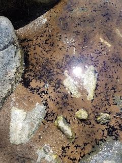

Comments
Post a Comment